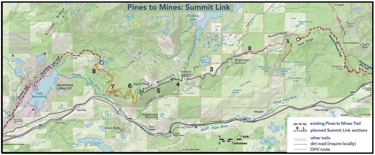
Section 1 - Granite Wall

This 13,293-foot (2.5 mile) section is the easternmost section, connecting to the existing Hole in the Ground Trail. This section has everything a high Sierra trail can offer – stunning granite, a lush conifer forest canopy, lovely tarns, and of course the cleanest air.
Section 2 - Southside

This 11,340-foot (2.1 mile) section runs through second-growth forest, with beautiful patches of wildflowers in late spring. Section 2 runs along a largely a northern facing slope that is mostly. shaded and cooler.
Section 3 - Long Ridge

This 15,682-foot (2.9 mile) section will allow users to avoid the sometimes-busy dirt Rattlesnake Road and the steep ups and downs of the 4x4 Lake Sterling Spur. It gently descends from Rattlesnake Road, west of Magonigal Summit, to Lake Sterling Road. There will not be a great deal of elevation change in this section, and it will be an excellent opportunity to experience the grand vistas of the crest to the south and endless carpets of wildflowers when in season.
Section 4 - Fordyce

This 9,790-foot (1.8 mile) section comprises three distinct areas: 1) to the east, a 0.2-mile boulder field, 2) a middle section of open forest, and 3) to the west, a rock ledge behind a tarn (a small lake at the base of a mountain), leading to a short 150-foot elevation change on a 5% grade. A short stroll off the trail here will reveal the wall of granite surrounding Fordyce Summit.
Section 5 - Red Mountain
This 15,613-foot (2.9 mile) section traverses the south face of Red Mountain between Signal Peak Road and Forest Road 13E59, providing an alternative to the most grueling climb on the current fire and jeep roads. Trail users will be amazed by the expanse of red rock as they cross the face of Red Mountain, with more grand vistas to the south.
Section 6 - Red Mtn Drop

This 7,840-foot (1.5 mile) section transitions from rocky rubble on Red Mountain in the east to second-growth forest in the west. The trail will be a pleasant alternative to hiking or riding on the existing jeep road.
Section 7 - Jeep Rd Drop
Section 7 - Jeep Rd Drop
This 27,138-foot (5.1 mile) section runs through second-growth forest. Trail users will appreciate a well-built trail that makes the steep descent (or ascent) a more manageable experience. In the fall, colorful oak trees along the trail will be stunning.
Section 8 - Eagle Lakes
Section 7 - Jeep Rd Drop
This 10,100-foot (1.9 mile) section will ultimately connect to the existing Spaulding Lake Trail via a new bridge over Fordyce Creek, passing the beautiful Eagle Lakes, full of lily pads along the way. Most of this trail will meander on granite slab.
Explore
Explore

Once completed, Pines to Mines will be one of the only long-distance, single track, multi-use backcountry trail for hikers, bikers, and equestrians in the region. The Pines to Mines Trail Alliance is a partnership between Tahoe National Forest, Bear Yuba Land Trust, Truckee Trails Foundation, Truckee Donner Land Trust, Gold Country Trails Council, Bicyclists of Nevada County, and Nevada County.
This trail project will cost an estimated $2 million to construct in total, broken into eight unique sections of trail.

Section 1 - Hole in the Ground/Granite Wall
Granite Wall Trail Features:
This 13,293-foot (2.5 mile) section is the easternmost section, connecting to the existing Hole in the Ground Trail. This section has everything a high Sierra trail can offer – stunning granite, a lush conifer forest canopy, lovely tarns, and of course the cleanest air.
Construction Highlights:
Construction access will require a high-clearance vehicle for traveling east on the unimproved Rattlesnake Road. Machine access would be from Hole in the Ground single track or Rattlesnake Road from a suitable point west of its crossing. Construction challenges through mostly open forest are moderate, with granite slabs, boulders, and a rocky subsurface to navigate. Numerous armored rock crossings will be required and possibly two small bridges which could be milled from trees in the area.
Granite Wall Construction Timeline: Summer 2026
How You Can Help
The P2M Alliance provides a variety of giving opportunities to best suit any potential supporter.
The P2M Alliance needs to raise the full $2.2M in funding to complete the P2M Trail over the next two years.
Granite Wall - Section 1 Budget Expense
Trail Construction (Approx.): $200,000
US Forest Svc Monitoring: $3,750
Signage/Other Amenities: $10,000
__________________________________________
Total: $213,750
Please contact Cory Caldwell, Executive Director, Truckee Trails Foundation, with your interest.
• (530) 587-8214
All funds raised by TTF and its P2M Partners will be directed to Truckee Trails Foundation, the lead on P2M trail construction.
Section 2- Southside
Southside Trail Features
This 11,340-foot (2.1 mile) section runs through second-growth forest, with beautiful patches of wildflowers in late spring. Section 2 runs along a largely a northern facing slope that is mostly shaded and cooler.
Construction Highlights
Numerous armored rock crossings will need to be constructed due to snow melt drainage areas. The terrain varies from large clearings to thick brush and large tree growth, but construction should proceed rapidly with machine and hand crew. Crew and equipment access is excellent via the unimproved Rattlesnake Road.
Southside Construction Timeline: Summer 2026
How You Can Help
The P2M Alliance provides a variety of giving opportunities to best suit any potential supporter. The P2M Alliance needs to raise the full $2.2M in funding to complete the P2M trail over the next two years.
Southside - Section 2 Budget Expense
Trail Construction (Approx.): $100,000
US Forest Svc Monitoring: $3,750
Signage/Other Amenities: $10,000
__________________________________________
Total: $113,750
Please contact Cory Caldwell, Executive Director, Truckee Trails Foundation, with your interest.
• (530) 587-8214
All funds raised by TTF and its P2M Partners will be directed to Truckee Trails Foundation, the lead on P2M trail construction.
Section 3 - Long Ridge
Long Ridge Trail Features
This 15,682-foot (2.9 mile) section will allow users to avoid the sometimes-busy dirt Rattlesnake Road and the steep ups and downs of the 4x4 Lake Sterling Spur. It gently descends from Rattlesnake Road, west of Magonigal Summit, to Lake Sterling Road. There will not be a great
deal of elevation change in this section, and it will be an excellent opportunity to experience the grand vistas of the crest to the south and endless carpets of wildflowers when in season.
Construction Highlights
While driving access to the western end is straightforward on improved dirt roads, access to the eastern end via the unimproved Rattlesnake Road is slower and requires a high-clearance vehicle to haul a trailer. With one approximately 100-yard exception, construction challenges across the generally steep side-slope are minimal. Two drainages will require armored rock crossings. The exception is a volcanic rock formation with at least two pinch points to negotiate. It will require extensive rock work and likely retaining walls constructed from existing rock in the area.
Long Ridge Construction Timeline: Completed Summer 2025
How You Can Help
The P2M Alliance provides a variety of giving opportunities to best suit any potential supporter. The P2M Alliance needs to raise the full $2.2M in funding to complete the P2M trail over the next two years.
Long Ridge - Section 3 Budget Expense
Trail Construction (Approx.): $82,000
US Forest Svc Monitoring: $3,750
Signage/Other Amenities: $10,000
__________________________________________
Total: $95,750
Please contact Cory Caldwell, Executive Director, Truckee Trails Foundation, with your interest.
• (530) 587-8214
All funds raised by TTF and its P2M Partners will be directed to Truckee Trails Foundation, the lead on P2M trail construction.
Section 4 - Fordyce
Fordyce Trail Features
This 9,790-foot (1.8 mile) section comprises three distinct areas: 1) to the east, a 0.2-mile boulder field, 2) a middle section of open forest, and 3) to the west, a rock ledge behind a tarn (a small lake at the base of a mountain), leading to a short 150-foot elevation change on a 5% grade. A short stroll off the trail here will reveal the wall of granite surrounding Fordyce Summit.
Construction Highlights
The .2 mile boulder field at the east end of Section 4, and the six switchbacks and steep terrain at the west end of the section will make construction very slow and technical. However, access for construction is straightorward via improved dirt roads.
Fordyce Construction Timeline: Summer 2027
How You Can Help
The P2M Alliance provides a variety of giving opportunities to best suit any potential supporter. The P2M Alliance needs to raise the full $2.2M in funding to complete the P2M trail over the next two years.
Fordyce - Section 4 Budget Expense
Trail Construction (Approx.): $230,000
US Forest Svc Monitoring: $3,750
Signage/Other Amenities: $10,000
_________________________________________
Total: $243,750
Please contact Cory Caldwell, Executive Director, Truckee Trails Foundation, with your interest.
• (530) 587-8214
All funds raised by TTF and its P2M Partners will be directed to Truckee Trails Foundation, the lead on P2M trail construction.
Section 5 - Red Mountain Traverse/Signal Peak
Red Mountain Traverse Trail Features
This 15,613-foot (2.9 mile) section traverses the south face of Red Mountain between Signal Peak Road and Forest Road 13E59, providing an alternative to the most grueling climb on the current fire and jeep roads. Trail users will be amazed by the expanse of red rock as they cross the face of Red Mountain, with more grand vistas to the south.
Construction Highlights
Access for construction is relatively easy from Cisco Grove via the improved dirt roads (Rattlesnake, Lake Sterling, and Fordyce Lake Roads) and Signal Peak fire road. Challenges to construction include the extreme side-slope, unstable rock surface, and nine turns along the ridge's nose that will require rock reinforcement to properly shape the turns. This section will require extensive machine and handwork and will be very technical.
Red Mountain Traverse Construction Timeline: Summer 2027
How You Can Help
The P2M Alliance provides a variety of giving opportunities to best suit any potential supporter. The P2M Alliance needs to raise the full $2.2M in funding to complete the P2M trail over the next two years.
Red Mountain Traverse - Section 5 Budget Expense
Trail Construction (Approx.): $450,000
US Forest Svc Monitoring: $3,750
Signage/Other Amenities: $10,000
_________________________________________
Total: $463,750
Please contact Cory Caldwell, Executive Director, Truckee Trails Foundation, with your interest.
• (530) 587-8214
All funds raised by TTF and its P2M Partners will be directed to Truckee Trails Foundation, the lead on P2M trail construction.

Section 6 - Red Mountain Drop Off
Red Mountain Drop-Off Trail Features
This 7,840-foot (1.5 mile) section transitions from rocky rubble on Red Mountain in the east to second-growth forest in the west. The trail will be a pleasant alternative to hiking or riding on the existing jeep road.
Construction Highlights
Six tight turns across a seasonal drainage near Forest Road 13E58 will require close attention to grade and shape. Construction access is similar to Section 5, with difficult OHV roads west of Signal Peak.
Red Mountain Drop-Off Construction Timeline: Summer 2027
How You Can Help
The P2M Alliance provides a variety of giving opportunities to best suit any potential supporter. The P2M Alliance needs to raise the full $2.2M in funding to complete the P2M trail over the next two years.
Red Mountain Drop-Off — Section 6 Budget Expense
Trail Construction (Approx.): $150,000
US Forest Svc Monitoring: $3,750
Signage/Other Amenities: $10,000
_________________________________________
Total: $163,750
Please contact Cory Caldwell, Executive Director, Truckee Trails Foundation, with your interest.
• (530) 587-8214
All funds raised by TTF and its P2M Partners will be directed to Truckee Trails Foundation, the lead on P2M trail construction.
Section 7 - Jeep Road Drop
Jeep Road Drop-Off Trail Features
This 27,138-foot (5.1 mile) section runs through second-growth forest. Trail users will appreciate a well-built trail that makes the steep descent (or ascent) a more manageable experience. In the fall, colorful oak trees along the trail will be stunning.
Construction Highlights
The major construction challenge is the 18 turns required to manage an 800-foot elevation change over two miles. It is rocky and will be technical. East and west of this pitch the terrain is mostly gentle, though numerous drainages in the west must be negotiated. Armored rock crossings will be required to cross numerous drainages. Trailer parking for machine access is available at the Eagle Lakes Staging Area.
Jeep Road Drop-Off Construction Timeline: Summer 2027
How You Can Help
The P2M Alliance provides a variety of giving opportunities to best suit any potential supporter. The P2M Alliance needs to raise the full $2.2M in funding to complete the P2M trail over the next two years.
Jeep Road Drop-Off - Section 7 Budget Expense
Trail Construction (Approx.): $600,000
US Forest Svc Monitoring: $3,750
Signage/Other Amenities: $10,000
_________________________________________
Total: $613,750
Please contact Cory Caldwell, Executive Director, Truckee Trails Foundation, with your interest.
• (530) 587-8214
All funds raised by TTF and its P2M Partners will be directed to Truckee Trails Foundation, the lead on P2M trail construction.
Section 8 - Eagle Lakes
Eagle Lakes Trail Features
This 10,100-foot (1.9 mile) section will ultimately connect to the existing Spaulding Lake Trail via a new bridge over Fordyce Creek, passing the beautiful Eagle Lakes, full of lily pads along the way. Most of this trail will meander on granite slab.
Construction Highlights
This section poses many unique challenges due to mostly granite slabs and difficult access for crews and equipment. NOTE: This section hasn’t been assessed on the ground yet, so trail construction costs below are estimated.
Eagle Lakes Construction Timeline: Summer 2027
How You Can Help
The P2M Alliance provides a variety of giving opportunities to best suit any potential supporter. The P2M Alliance needs to raise the full $2.2M in funding to complete the P2M trail over the next two years.
Eagle Lakes - Section 8 Budget Expense
Trail Construction (Approx.): $350,000
US Forest Svc Monitoring: $3,750
Signage/Other Amenities: $10,000
_________________________________________
Total: $363,750
Please contact Cory Caldwell, Executive Director, Truckee Trails Foundation, with your interest.
• (530) 587-8214
All funds raised by TTF and its P2M Partners will be directed to Truckee Trails Foundation, the lead on P2M trail construction.